Innovation Days at terrestris, also simply called “playdays” internally, have been fixed dates in our calendar for several years. On Innovation Days, the employees determine the content of their day themselves – against the background of trying out new things or simply developing or testing software or techniques. In other words, things for which day-to-day business sometimes leaves no room. In short, Innovation Days are project-free creative breaks from what we otherwise do. Success confirms this concept: some of our working methods, offers or features had their beginnings on one of these days. Today we report on the developments of the last Innovation Day in September.
QGIS as an open source desktop GIS is becoming increasingly popular and we too have handled projects related to QGIS in the past. QGIS 3.0, a new version, will be available shortly – one question on Innovation Day was how much effort it would take to migrate existing QGIS PlugIns for QGIS 2.x to the new version, because the move to QGIS 3.x also means that they must at least be adapted. One result was that, as expected, no general statement can be made, but that a move is fundamentally possible. As a small side product, our developer Andreas Schmitz has developed a QGIS PlugIn which allows to add our OWS-WMS services in QGIS at the push of a button. The PlugIn is of course available on Github.
 Another topic to which two developers have dedicated themselves are Vector Tiles. Vector Tiles (MVT) are pre-processed map tiles in which geodata is delivered as vectors in a specific format to a client. The latter is then responsible for the design of the data. Johannes Weskamm dealt with the optimal positioning of labels for street names and developed, among other things, a collision detection for labels in OpenLayers. Since we want to provide and use our OSM-WMS in this format in the future, these developments are an essential component for this overall project. We hope to be able to share our findings with the OpenLayers project here. Daniel Koch has tested this technology based on the GeoServer VectorTiles-Extension in combination with OpenLayers for possible use in our new applications (especially those based on react-geo). The focus here was on our high demands on performance and the implementation possibilities of the sometimes very complex style guidelines.
Andre Henn dealt with the GeoServer administration interface and the question of how far it can be individualized. His conclusion, also visible in the screenshot below, is that the GUI can be adapted relatively easily to project- or customer-specific requirements. The example below shows a design in the terrestris style. 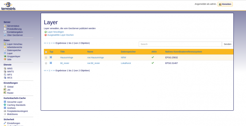
Finally, Marc Jansen dealt with automated tests of our web applications using the software Puppeteer. With Puppeteer you can remotely control a Chrome browser, and take screenshots at any point, but also execute code on the respective website. In this way, he was able to check whether it is possible to log into the SHOGun backend and whether the logged-in user is assigned the correct role. Then it is checked whether a GIS client can be called up from the administration backend. Puppeteer is actively developed and has a very nice API that can be used wonderfully from Node.js projects. The tests delivered very promising results, a general use of Puppeteer has since been discussed internally.