^

Map Viewer API GeoBasis Brandenburg

The State Survey and Geobasisinformation Brandenburg (LGB) is the central provider of geoinformation in Brandenburg and operates several web portals with integrated map viewers. Previously, however, there was no uniform appearance – either functionally or in terms of design. With the development of a new map viewer API based on Masterportal, a modern, recognizable and flexible solution has been created.

Challenge

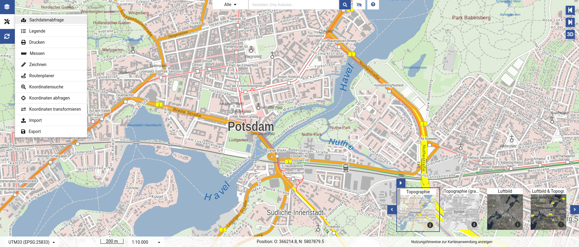
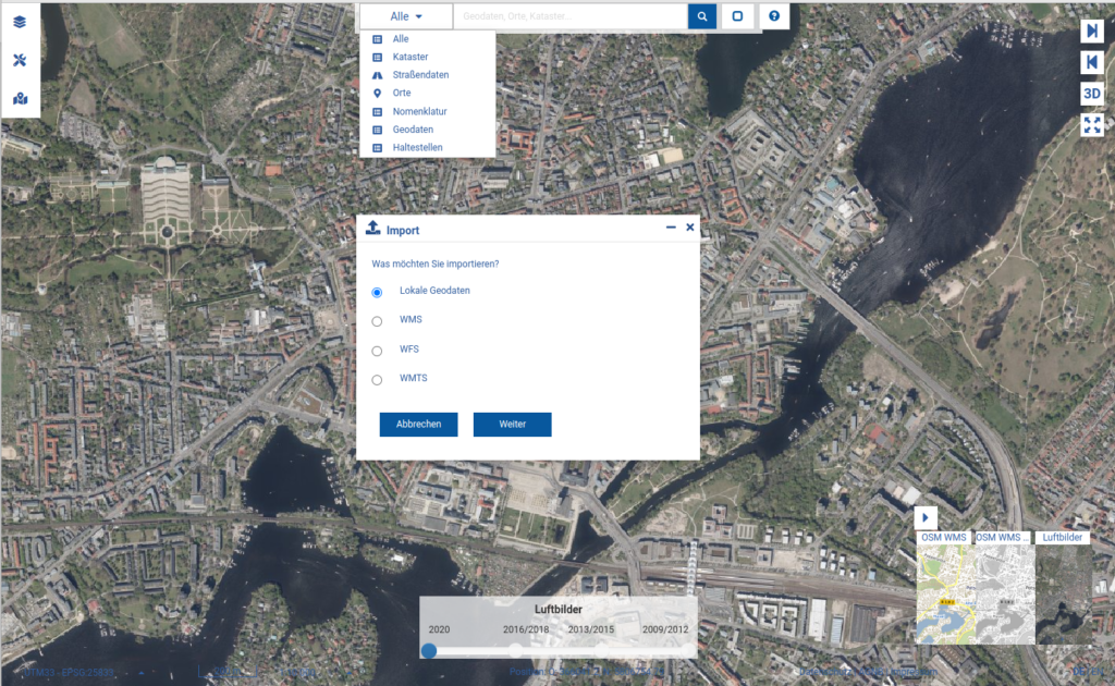
The development of a modern and user-friendly map client was an exciting challenge. The aim was to implement the design and usability standards defined in a previous project and at the same time technically expand the existing Masterportal in such a way that complex functions such as data import/export, coordinate transformations and flexible layer management are easily possible. In addition, the portal should be seamlessly integrated into existing web portals and a uniform appearance should be ensured.

Services

  • The following measures were implemented to meet these requirements:
  • Development of a new map viewer API based on the open source software Masterportal
  • Implementation of a modern UI/UX concept in accordance with the specifications of a previous design project
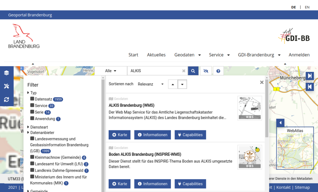
  • Integration of external WMS services and filter functions for the targeted reloading of layers
  • Implementation of a powerful search function with:
    • Filter options
    • Pagination
    • Preview and detail views
    • Direct data import into the portal
    • Connection to an Elasticsearch interface
  • Extension of the service manager to:
    • Management of services and layers
    • automatic generation of layer lists
    • direct communication between frontend and backend
  • Development of an add-on for integrating the Masterportal into existing web portals via a top-level API (including topic tree control, map storage, service import, search)

Result

The result is a powerful, modular WebGIS with a modern, uniform appearance, extensive functionality and high user-friendliness. The solution is future-proof, flexibly integrable and forms the basis for a long-term consistent provision of geodata in all web portals of the LGB.

Customer

State Survey and Geobasisinformation Brandenburg

Map Viewer API GeoBasis Brandenburg

The LGB is the central provider of geoinformation in Brandenburg and operates several web portals with integrated map viewers. Previously, however, there was no uniform appearance – either functionally or in terms of design. With the development of a new map viewer API based on Masterportal, a modern, recognizable and flexible solution has been created.

As part of the project, the new map viewer API of the LGB was technically implemented based on the open source software “Masterportal“. Previously, a design and usability concept was developed in a separate predecessor project (also processed by terrestris), which contains specifications for a modern, appealing and future-proof map client.

During the project, the individual design options of the portal were significantly expanded, which enables both the configuration of the general appearance (theme) and the adaptation of details. In addition, the functionality of the Masterportal has been significantly expanded, for example through the implementation of generic tools for data import and export, coordinate transformation, projection and background map switcher, and the improvement of the drawing tool. Another important focus was on the development of a new search function in close cooperation with the clients. The search function offers various filter options, pagination, preview of search results, detail views and enables direct import of data into the portal. An Elasticsearch interface serves as the search backend.

Furthermore, an add-on was developed that makes it possible to integrate a Masterportal instance into existing portals, for example into CMS-based websites. For this purpose, various interfaces were implemented as so-called “top-level API” in order to be able to control the portal, such as the state of the topic tree (thematic maps), the saving of the map view, the import of services or the control of the search.

For the management of services and layers as well as for the automatic generation of layer lists for the Masterportal, the open source software “Dienstemanager” was functionally expanded within the scope of the project and adapted to the GDI of the LGB. The service manager ensures the connection to the Elasticsearch interface, extends the properties of layers and enables direct communication between the client-side Masterportal instance and the service manager backend.

Since the completion of the development project, software updates are carried out regularly and further functionalities are developed as part of the maintenance/support contract.

The goal was to standardize the graphic appearance and provide the full range of functions in all web portals of the LGB.

The development of a new map viewer API for the individual creation of modern WebGIS clients based on the open source software Masterportal.

Challenge

The goal was to standardize the graphic appearance and provide the full range of functions in all web portals of the LGB.

Result

The development of a new map viewer API for the individual creation of modern WebGIS clients based on the open source software Masterportal.

Services

Masterportal
Elasticsearch
Design and Usability Concept

Story