CesiumJS is a modern, open-source JavaScript library for developing interactive 3D maps and globe-based web applications. It runs directly in the web browser – without any additional plugins or external software. CesiumJS is ideal for applications in areas such as spatial planning, geodata visualization, or simulation, where spatial information is to be presented in three dimensions.
Display of 3D–data on the web
The areas of application are diverse – from subsurface modeling and smart city applications to analyses in the field of Building Information Modeling (BIM) or environmental monitoring. The full analysis potential of many data can only be exploited by incorporating the third dimension. For example, we have already used Cesium to display cell towers in urban areas or to visualize geological structures in scientific projects.
Thanks to WebGL, CesiumJS offers high-quality graphics performance directly in the browser. The library supports various data formats such as 3D Tiles, 3D Tiles Next, KML, and GeoJSON for dynamic visualizations. By using the 3D Tiles standard, city models and terrain data can be efficiently visualized. The library has a modular structure and can be flexibly integrated into existing web applications.
Our services:
- Development of individual 3D web applications
- Integration of 3D Tiles, point clouds, and other geodata sources
- Connection of Cesium to existing GIS/GeoServer services
- Extension of existing Cesium applications
- Development of analysis and visualization tools
- Consulting and conception of 3D GIS architectures on the web
- Hosting and optimization of 3D data for high-performance web applications
Advantages of Cesium:
- Supports numerous data formats, including:
- 3D Tiles
- Point Clouds
- KML, GeoJSON, and CZJM
- Raster data (pre-calculated tiles) and services (such as WMS)
- High performance with flexible map modes: 3D, 2D, and 2.5D views
- Web-based through WebGL – no plugin required
- Runs on mobile and stationary devices
- Expandable with modern frameworks, e.g., React
- Precise navigation in space with support for time animations
- Open source with active community
For a deeper insight into Cesium, we recommend taking a look at the official GitHub repository, the interactive Sandcastle demo, and the documentation. Further information can also be found on the Cesium website.
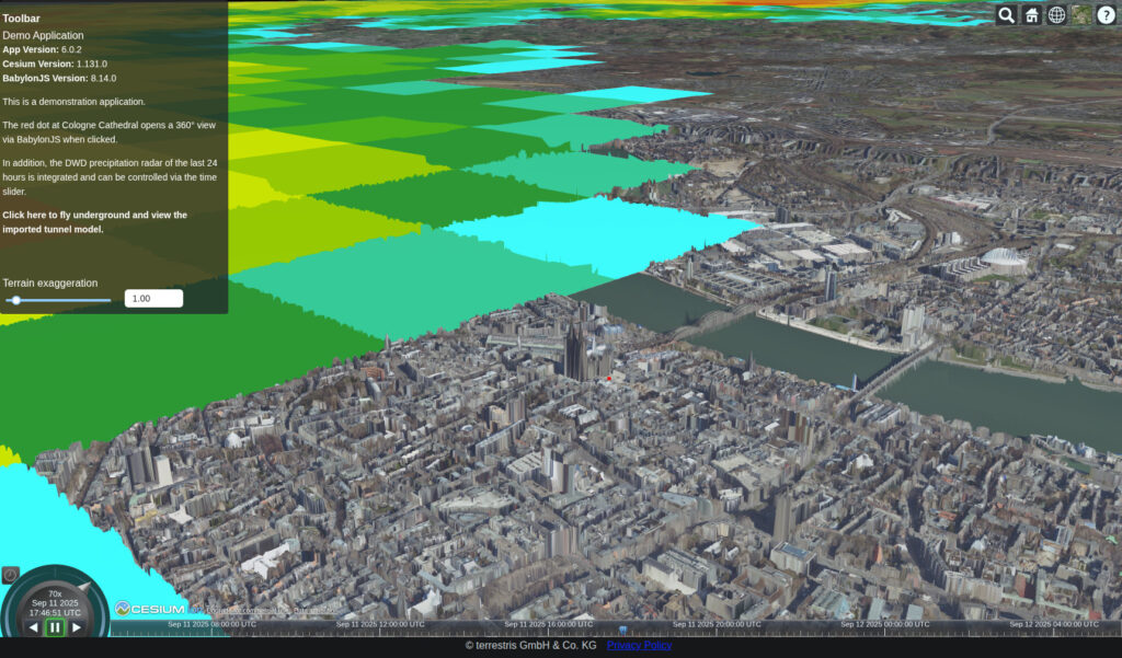
Video of a CesiumJS application: Interactive zoom from the entire globe to a point in Cologne, in which a navigable 360° panorama of the forecourt of Cologne Cathedral is displayed. The digital orthophotos visible in the meantime are queried from a WebMapService (WMS) and projected onto the globe.
We are happy to support you throughout your entire project – from the initial consultation to long-term support. Our team ensures that your application runs smoothly and is optimally tailored to your requirements.
Contact us for a non-binding consultation and find out how 3D applications can make your data more efficient and tangible.