In the event of increased radioactivity measurements, rapid and targeted measures are necessary to protect the population. Terrestris is developing a modular application for the Federal Office for Radiation Protection that processes data from over 2,000 measuring points across Germany and makes it usable for rapid decisions.
The nuclear phase-out in Germany is a done deal. But since Chernobyl, Fukushima, and most recently the discussions about the safety of the nuclear reactor in Tihange, Belgium, it is clear that radiation protection will continue to be a concern. But what needs to be done in the event of an incident, when radioactive radiation is released due to a reactor accident? Only rapidly available and reliable information and forecasts about a radioactive cloud or the contamination of the environment make suitable protective measures possible.
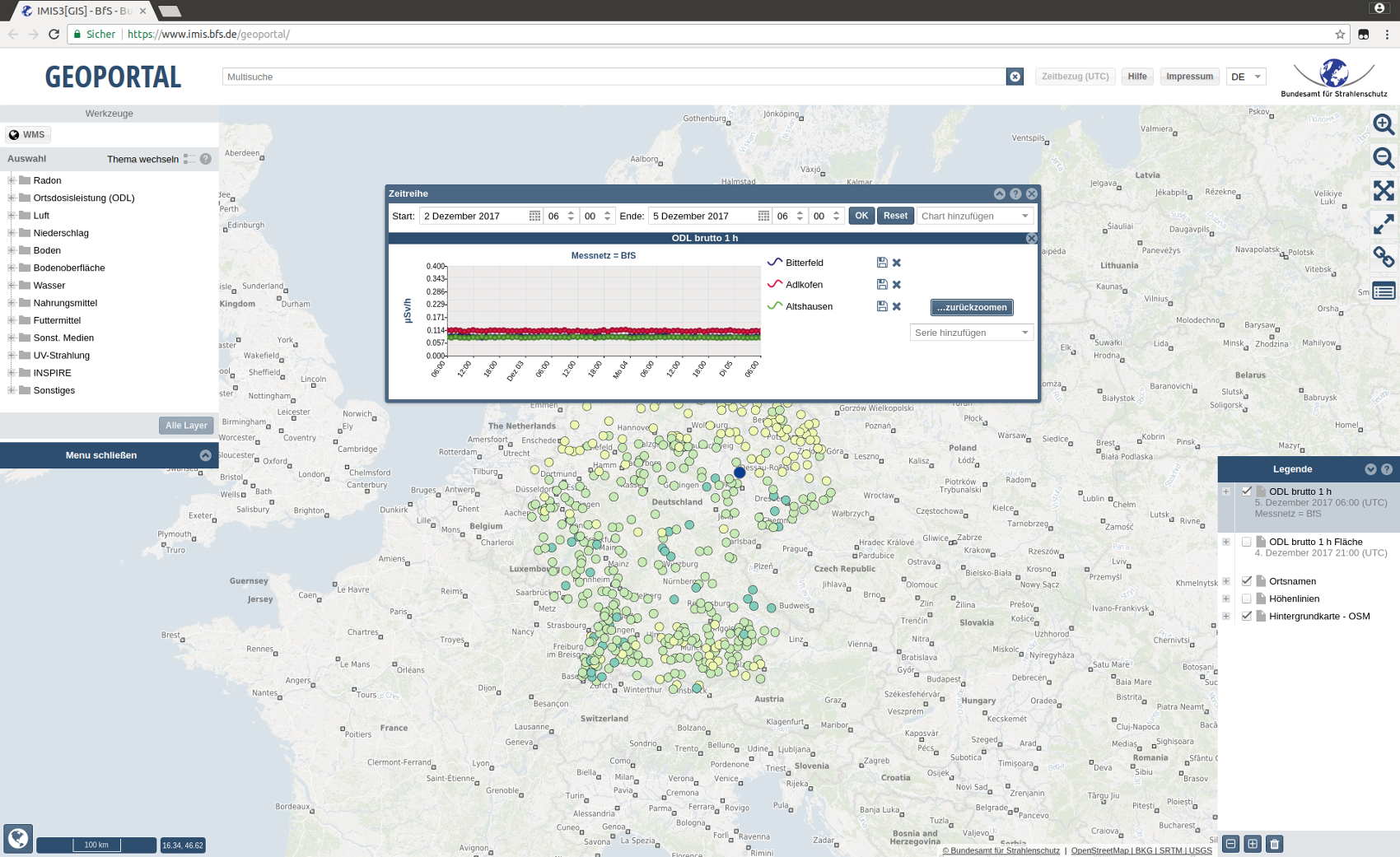
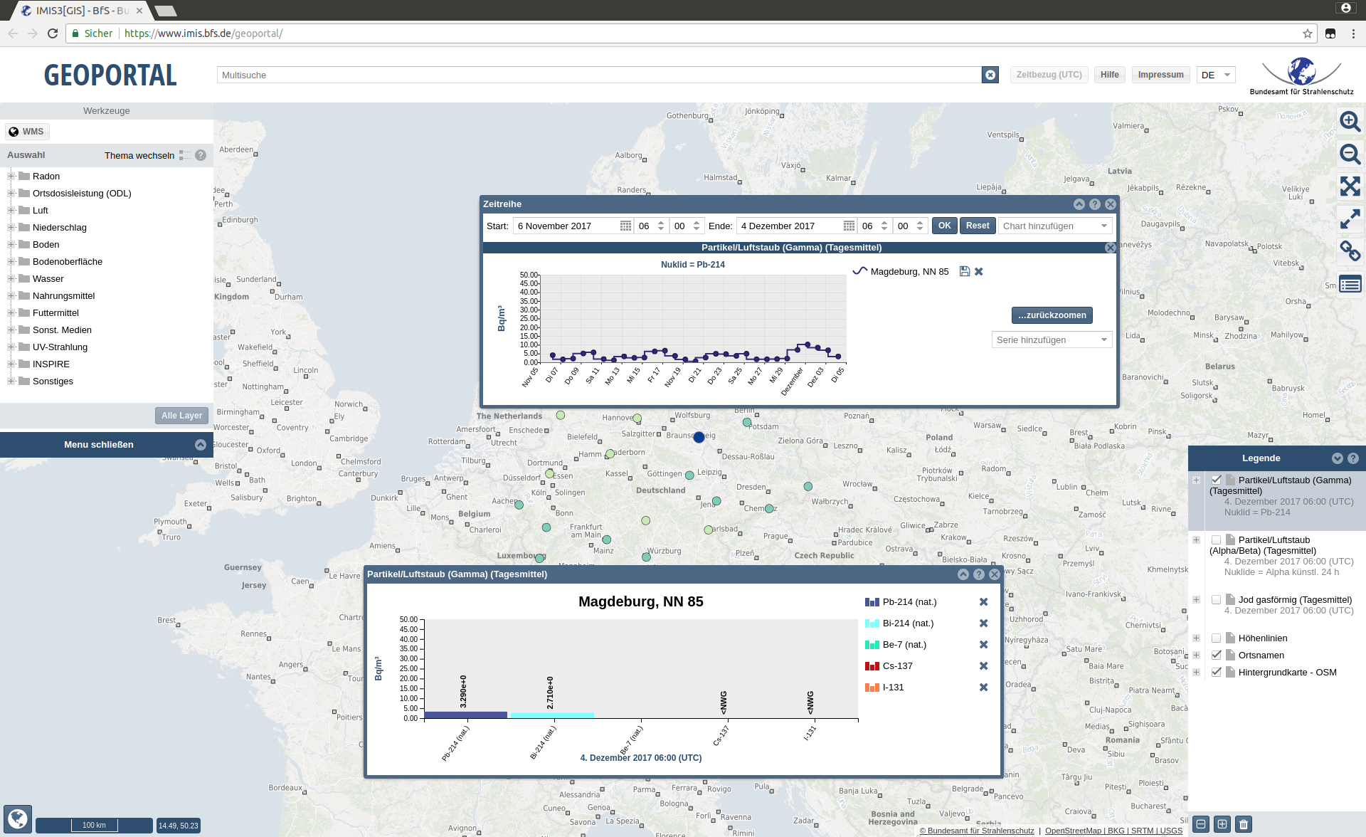
At the federal level, the Federal Office for Radiation Protection (BfS) is responsible for emergency preparedness. It operates the Integrated Measurement and Information System for Monitoring Environmental Radioactivity (IMIS). Terrestris GmbH & Co. KG, based in Bonn, has developed a configurable application for the BfS for optimal monitoring of the collected data. IMIS continuously measures radioactive radiation in the environment at approximately 1,800 measuring points throughout Germany. In addition, there is a wealth of measurement data from other institutions, such as the German Weather Service, the Federal Institute for Hydrology, and the State Offices for the Environment and Nature. IMIS also collects measurement data from over 60 laboratories and from measuring stations abroad.
Individually configurable application
The geoportal makes all this data available to everyone on the Internet. “This fulfills our legal obligation to make the collected data transparent and generally usable by the public,” says Sven Burbeck from the BfS. The new application makes it possible to integrate this data into maps and diagrams that can be configured as needed. One click is enough to modify the map with an additional function: e.g. by changing the scale and zoom function, filter and edit functions for location search or time series for measured precipitation and their updating.
“A map says more than a thousand pictures,” explains Till Adams, Managing Director of terrestris, the task. “The aim was not to generate statistical images. Rather, we bring data together in an interactive map. This allows the information to be presented according to individual questions.”
The BfS uses the developed software in particular to carry out its tasks in the area of emergency protection, but also uses parts of the application to make the information available to everyone on the Internet (https://www.imis.bfs.de/geoportal/). With the geoportal, the BfS is contributing to presenting and publishing data collected by authorities in a transparent manner, thereby making it generally usable.
 Processing a diverse amount of data
With IMIS, the BfS permanently monitors radioactivity in the environment. There is a probe approximately every 20 kilometers; in the area of nuclear power plants, the special network is denser. Each measuring point permanently measures the local dose rate. Normally, this is the natural radiation exposure from radionuclides in the air and soil as well as cosmic radiation from space.
Individual values are useless for an assessment. What is needed is data over longer periods of time, which must be available immediately in order to quickly detect contamination in the event of an incident and to be able to estimate the expected radiation exposure. The probes can be queried every 10 minutes for the necessary measured values. “This leads to a huge amount of diverse data, which we can now display multidimensionally in maps and charts in a very short time,” says Ulrich Rothstein, project manager at terrestris. A radioactive cloud can thus be observed in real time.
In addition to the visualization and filter functions, the application fulfills another important requirement: it offers a printing option. Each map can be converted into a PDF file and thus into a printable document. An important prerequisite for official decisions, which must be permanently comprehensible and legally sound.
Geo-infrastructure with Open Source
The project is also internationally oriented within the framework of radiological emergency protection. The collected data is also exchanged directly with the state authorities and authorities in neighboring countries as well as the EU, which is why it is also possible to visualize the measurement results of the other authorities with the WebGIS application.
In order to further develop its system for monitoring radioactivity, the BfS relies on open source. For the developers at terrestris, this means not simply developing new software, but integrating the new application into the existing open source structures of the BfS.
For the implementation, the developers used open source components such as OpenLayers to display the data in the web browser. Likewise GeoServer for the processing of the geographic data and location-based information as well as MapFish Print for printing the maps as PDF. GeoNetwork open-source and GeoExt were also used.
 Cooperation as knowledge transfer
New legal regulations and changing requirements for user-friendliness ensure that the application has to be constantly developed further. The cooperation is therefore not completed with the development of the software.
“New questions arise regarding the data to be processed, which have to be solved. The cooperation with the Federal Office is correspondingly close and trusting,” says Ulrich Rothstein. “The code is being updated, the software is being maintained and optimized. Our task also includes developer training at the BfS. In this respect, we see our work as a transfer of knowledge from which the public also benefits.”
The application, like all open source solutions, can also be used and further developed by other interested parties, authorities or companies that deal with similar issues.